← All products

Warsaw, Poland Map

Warsaw City

X-Plane 11

Follow the Vistula through central Warsaw, passing the skyline and river bridges on the way to airfields around the capital.
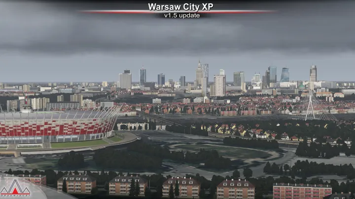
City skyline under storm clouds · Warsaw City

Scenery features

City and terrain

Aerial imagery covers about 5,000 square kilometres, with custom landmarks and buildings placed from local and OpenStreetMap data.

Local flying sites

A network of airfields and heliports includes Modlin and Babice. Warsaw Chopin Airport is available as a separate scenery.

Roads, railways and lighting

Simulated road and rail traffic follows the city’s transport routes, with native HDR lighting after dark.

Screenshots

Show 66 more screenshots
  • Stadium seen through cabin window
  • Aircraft banking above landscape
  • Warsaw streets beside Vistula
  • City park and riverbank
  • Old town streets and spires
  • Palace of Culture on skyline
  • Tower above palace façade
  • Cable-stayed bridge seen from below
  • Stadium behind bridge pylon
  • National Stadium beside river
  • Terminal buildings across runway
  • Rail corridor through city
  • Urban districts and surrounding fields
  • Bridge cables above river
  • Bridge and river bend from altitude
  • City streets near stadium
  • Skyline beyond broad neighbourhoods
  • Warsaw from altitude
  • River winding between districts
  • Sailboat on broad waterway
  • Aircraft taxiing in sunset light
  • Grass verge along runway
  • Passengers and bus below aircraft
  • Cars and bus at terminal entrance
  • Fenced airfield building
  • Checkered control tower
  • Urban runway beside woodland
  • River and industrial buildings
  • Aircraft on apron beside runway
  • Aircraft parked on grass at night
  • Runway centreline lights
  • City lights beyond dark airfield
  • Service vehicle on night apron
  • Long hangar beside taxiway
  • Aeroclub sign on building
  • Colourful light aircraft beside hangar
  • Sandy ground beside forested runway
  • Airport building and crossing roads
  • Glider outside blue hangar
  • Taxiway sign beside grass
  • Light aircraft on grass between strips
  • Blue-trimmed hangar beside apron
  • Light aircraft inside steel-roofed hangar
  • Ultralight wing by open hangar
  • Grass airstrip between fields
  • Illuminated hangar interior
  • Red light aircraft beside small hangars
  • Airfield fuel pump and tanker
  • White two-storey airfield building
  • Desk overlooking runway
  • Aircraft at open hangar doorway
  • Grass runway through green field
  • Grass airfield and boundary road
  • Open-frame tower over service bay
  • Small airfield building and grass
  • Windsock above trees
  • Ultralight outside green hangar
  • Grass landing strip from above
  • Small aircraft beside white hangar
  • Covered walkway among trees
  • Sky sign on hangar wall
  • Twin hangars with open doors
  • Grass airstrip beside woodland
  • Ultralight aircraft on grass
  • Ultralight with blue wing
  • White-winged ultralight by hangar

Where to buy

Scenery retailers

Browse the full store directory

Installation & support

Simulator compatibility

Designed for X-Plane 11.

Installation

Remove earlier or overlapping scenery for the same location before installing. On Windows, run the supplied installer. On macOS or Linux, follow the manual installation guide included with the download.

Customer support has ended for this edition. No further updates will be released.

About the city and its airfields

The Vistula divides Warsaw between the historic centre on its higher western bank and the district of Praga to the east. The Royal Castle and the roofs of the Old Town overlook the river. Across the water, the National Stadium rises above the low-lying shore. Farther west, the Palace of Culture and Science and the office towers mark a separate centre of gravity in the skyline.

Warsaw from the Vistula

Much of the Old Town was destroyed during the Second World War. Its reconstruction drew on architectural records, historic views and surviving fragments of the original buildings. Seen from the river, the closely spaced roofs and church towers of the rebuilt district occupy a very different scale from the broad avenues and taller buildings of central Warsaw.

Aviation also left several distinct sites around the city. Early flying took place at Pole Mokotowskie, and passenger traffic later moved to Okęcie. Babice developed on the northwestern side of Warsaw and became an important general aviation field. Beyond the built-up area, smaller airfields and grass strips give the surrounding Mazovian countryside a character of its own.

Included airfields · EPMO, EPBC, EPNC, EPSJ, EPGO, EPKU, Ręczaje, Kroczewo, Trębki Nowe, Wincentów 1, EPW8, EPW4

Open original